


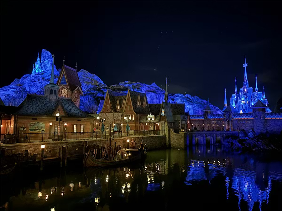
On Sunday, March 29, the new World of Frozen attraction—inspired by the eponymous animated film franchise—was inaugurated with great fanfare at the secondary park of Disneyland Paris, which was renamed Disney Adventure World for the occasion. But behind this historic expansion of the Parisian park, which features a recreated fjord and a 36-meter-high “Northern Mountain,” it is the iconic geological features of the Scandinavian and Alpine environments that are highlighted and thus made visible to the general public.
Remember the movie Frozen, in which, after revealing her powers, the main character, Elsa, takes refuge in an ice palace she builds at the foot of the Northern Mountain. It is this North Mountain, larger than life and rising 36 meters high, that has been recreated overlooking the “World of Frozen.” While this set piece is, of course, entirely man-made, it incorporates all the shapes and types of rock found in the imaginary depiction of the Nordic and alpine environment.
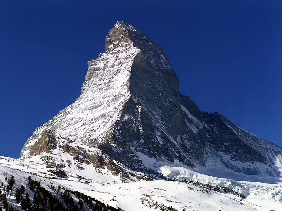
Thus, the first element visible to visitors entering the World of Frozen is this mountain in the form of an almost perfect pyramidal peak. This representation of the “ideal” mountain peak is directly inspired by the summit of the Matterhorn in the Swiss Alps.
The Matterhorn is a mountain that has become iconic since the early days of mountaineering and its first ascent in 1865. The Matterhorn’s pyramidal shape is the result of a combination of differential erosion—that is, erosion that affects rocks differently depending on their relative strength—and the very tectonic structure of the Alps. The Matterhorn is located in the center of the Alpine range, at the heart of a large thrust sheet—a geological formation that has undergone significant lateral displacement: the Dent Blanche thrust sheet. The rocks that make up the Matterhorn are primarily gneiss and granite in its lower section—very hard rocks—while its small summit section consists of paragneiss and schist, which erode much more easily. The very hard gneisses and granites that make up its base have allowed for the formation of very sharp ridges, which have resulted in this now-characteristic and instantly recognizable pyramidal shape.
Extinct volcano and Arthurian legend
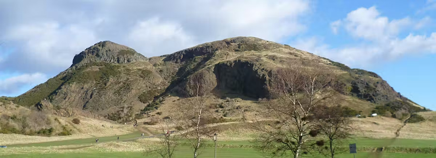
Once past this iconic first peak, the visitor’s gaze shifts to a gentler landscape: a succession of hills and plateaus whose base is clearly inspired by columnar basalt formations.
This landscape of gentle hills and grassy slopes overlooking a basalt formation and traditional dwellings is comparable to the volcanic terrain of Arthur’s Seat in Edinburgh, Scotland. At the end of the Royal Mile and adjacent to Holyrood Palace, the terrain of an ancient volcano defines the Scottish landscape. This ancient volcanic relief features typical basalt columns at its base, formed by the rapid cooling of lava flows, and gently sloping grassy summits.
Less well-known in France than the Matterhorn, Arthur’s Seat (or “Arthur’s Throne” in literal translation) is nonetheless iconic, making a direct reference to Arthurian legend.
Unlike the Matterhorn, which is composed primarily of gneiss and granite, Arthur’s Seat is of basaltic volcanic composition. It is in this juxtaposition between a volcanic base—against which a typical village rests—and a pyramidal summit that the reconstruction of the region’s iconic landscapes takes root. In nature, it would be unlikely to find a gneissic peak directly overlooking a volcanic flow. However, the juxtaposition of peaks that are mythical in form works because it appeals to our imagination while drawing on images deeply rooted in shared representations of mountains and Nordic landscapes.
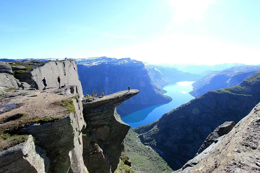
The fjord, Scandinavia's legendary valley
The entire new World of Frozen area, which stretches at the foot of the Northern Mountain, is centered around a fjord built from scratch, offering visitors a new venue for shows.
The fjord is a major geomorphological feature of the Scandinavian coastline, resulting from the complex interplay of glacial erosion and the refilling of valleys with water. It is an inland extension of the sea, surrounded by steep terrain shaped by glacial erosion.
During the last ice age, the ice sheet extended far south from the poles. Glaciers carved out the typical U-shaped glacial valleys or trough valleys throughout Western Europe, characterized by steep, high walls and a flat bottom. These valleys are also very deep due to the simultaneous drop in sea and ocean levels, which created an imbalance: rivers and glaciers had to carve deeper to reach the original sea level, as water was then trapped in the polar ice caps.
When the last ice age ended about 10,000 years ago, glaciers melted across Europe. The water, now in liquid form, caused sea levels to rise. This led to the flooding of abandoned glacial valleys, which became fjords in Scandinavia. But while fjords are primarily found along the coasts of Norway and Iceland, they also exist much closer to home in France; they are called abers in Brittany and calanques in Provence.
Trolls, or the Folklore of Erosion
Trolls are everywhere in the Frozen World: in the Frozen Ever After attraction, of course, but also as characters throughout the land, and even available for purchase as interactive figurines to take home. In Frozen, trolls are round, stocky creatures that easily blend in with rocks. This isn’t a random invention by the screenwriters, but a faithful reflection of a very ancient belief in Scandinavian folklore, itself rooted in observations of the eroded granite landscapes of Norway, Sweden, and Denmark.
Legend has it that trolls, caught off guard by sunlight, were turned to stone. That is why, all over Norway, rounded rock formations resemble their silhouettes: a hand, a back, a big nose. For the Nordic peoples, these anthropomorphic granite boulders were not the result of geological chance; they were the petrified remains of nocturnal creatures too slow to return to their caves.
The geological reality behind these shapes is just as remarkable as the myth. Granites—intrusive igneous rocks formed deep underground through the slow crystallization of magma—feature natural fractures that split them into blocks as they solidify. Weathering, caused by freezing, water, vegetation, and glaciers, primarily affects the corners and edges. This is the phenomenon of spheroidal erosion: the corners disappear first, and the cubic block gradually transforms into a sphere. These are then referred to as granite boulders, or sometimes granite chaos when they accumulate in spectacular clusters.
Northern geology made accessible to the general public
With the opening of its new area dedicated to Frozen, Disney once again draws inspiration from the landscapes and geology around us to ground its stories and settings in a shared imagination. Without realizing it, visitors who step through the doors of this universe are immersed in a collection of geological features that draw on the interactions between tectonics, volcanism, and erosive processes at work in northern Europe.
The world of “Frozen,” by recreating a 36-meter-high snow-capped mountain overlooking a fjord, thus offers visitors a kind of geological experience. Children who discover Elsa’s ice castle, the dark basalt cliffs, and the stone trolls will thus, without realizing it, be walking in the footsteps of the Matterhorn, the Norwegian fjords, Arthur’s Seat, and the granites of Scandinavia!
About the Authors
Élodie Pourret-Saillet, Associate Professor of Structural Geology, UniLaSalle
Olivier Pourret, Associate Professor of Geochemistry and Director of Scientific Integrity and Open Science, UniLaSalle


